Three Travel Times Are All You Need
So, I went searching for housing for a friend who was briefly visiting the area, sent them a couple promising listings, and then came the question...
"Is it in East Palo Alto?"
To orient our readers that're not from the Bay, "is it in East Palo Alto?" is a loaded question, one that I came to understand after moving to the area myself. East Palo Alto and Palo Alto share a name and a border, but not much else. East Palo Alto has historically been lower-income and carried a reputation for being less safe, though that reputation's been shifting.
With my friend's concerns in mind, I messaged the landlord to ask for the address, and as I hit the "send" button, the thought came to me...
Is there another way we can answer this question?
See, it's common etiquette for landlords to list out travel times on their postings, stuff like:
XX min walk from Caltrain, XX min bike to XYZ University Campus, XX min to SFO by car...
Staring at the travel times, a childhood memory hit me.
Shout-out to Redditor u/BuentinBarantino for digging the link to the game from the depths of the Internet archive.
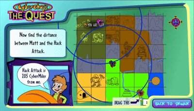
If you were a Gen-Zer who grew up watching PBS Kids, you probably remember Cyberchase. A formative experience for me was hopping onto the PBS Kids website to playing the games that were modelled after their TV shows, and among these games was Cyberchase: The Quest.
All you need to know about the game is that you get interrupted by Hack Attacks from a big bad villain who's literally named Hacker, and this drops you into a minigame where you must locate the Hack Attack by drawing three circles and looking at their intersection. This technique is called trilateration, and if you've ever wondered how GPSes work, now you know. :)
Struck by that flash of inspiration from the Cyberchase cinematic universe, I asked my friendly neighborhood LLM:
is there an app that lets me draw circles around locations where radius is based on how many minutes it takes to get to said location
for example, if a posting says "the house is a 12 min bike to Stanford, 22 min bike from Big Corp Office" i can draw two circles around the office and Stanford campus to derive the location of the house
and my friend the LLM asked me to check out TravelTime, which I did, and proceeded to enter two travel times from the posting:
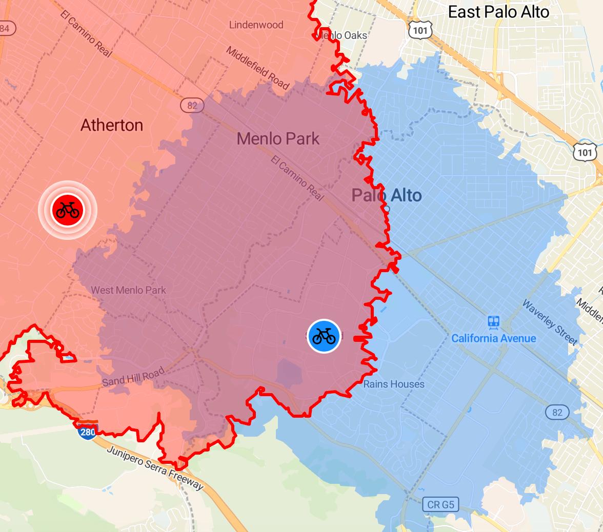
TravelTime went above and beyond what I needed - instead of two broad circles, it draws two isochrones. A little etymology lesson for you and me both, iso = equal, chrone = time, so isochrone's a very special line that connects points that have equal arrival times. :)
See how the intersection of the blue and red regions are squarely to the left of East Palo Alto?
So, the verdict was clear: no, the housing unit was not in East Palo Alto. We relay this news to our friend, and everyone's happy. Done!
Trilateration uses three for a reason
Two circles alone usually intersect at two points, leaving you with a whole region to search through, and also why I explicitly chose two travel times above to not dox the housing unit I was looking at.
Meanwhile, three circles is the magic number, since their intersection collapses down to one spot. This is why GPS satellites need at least three distance measurements to find your position on Earth.
Afterword: Holy Privacy
After celebrating this little victory with a mental high-five, I did what any reasonable person would do, which was stalk myself.
So, I picked three travel times from my apartment and entered them into TravelTime:
xx minutes drive from Stanford University
xx minutes drive from Meta MPK office
xx minutes drive from SFO airport
Then I looked at the intersection of blue, red, and orange regions, picked out the region that was closest to my actual apartment address, and, would you look at that, it was just 1.3 miles from my actual apartment address!
(screenshot not included for obvious reasons)
I have to say, this fact is unsettling and empowering at the same time. Now, whenever I see a list of travel times, whether it's a housing listing, a Craigslist post, or someone on Blind saying "20 min from Meta, 15 min from Google", I feel like I've got Shinigami eyes, and so do you.
Three travel times is all it takes! Use this power for good, and maybe keep your own travel times a little vague. :)